Table of Contents.
The Tuve Landslide, Sweden,1977.
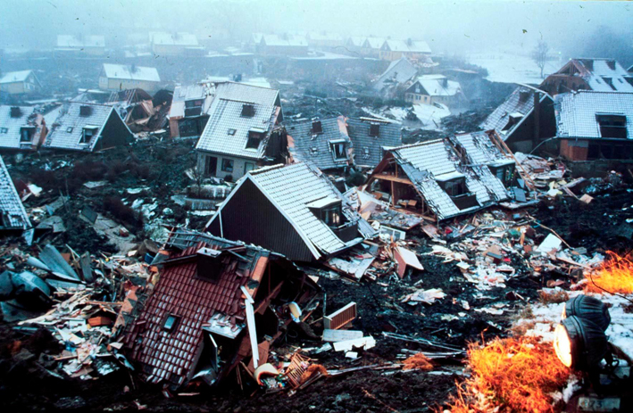
Houses collapsed in the Tuve district of
Gothenburg.
A landslide occurred in the district of Tuve in
Gothenburg on November 30, 1977. The landslide started shortly after 4
p.m. and lasted about 4 minutes. The devastation was great. Nine people
were killed and 65 homes were destroyed. The value of the destroyed was
estimated at about 50 million SW
Crowns
(5,1 million USD)
I have examined this event on the assumption that it is
part of the war on semen.
This operation contains all the usual elements that can
be attributed to the CIA's Nazis. To perform an operation like this,
expert knowledge in geotechnology was required. Of course, there were no
CIA agents who possessed such knowledge. "Consultants" have been hired
elsewhere. This is where my suspicions fall on people at Chalmers
University of Technology in Gothenburg. The CIA's planning for measures
after the landslide has included ensuring that "right" people were given
the task of investigating the landslide. It is noteworthy that already
on December 6, a research team from the US arrived in Gothenburg. They
spent three days in the city. They
published a report in 1980. It is concise.
It is unlikely that the researchers were able to arrive at any crucial
discoveries during their short time at Tuve. The
purpose of the CIA was to allow the researchers to establish the
framework for the Swedish investigation. Experts at Chalmers came to
participate. The foremost experts in geology in Sweden are found at the
Swedish Geotechnical Institute SGI, Linköping.
They have also submitted a number of reports on the landslide. What was
it then that the CIA wanted to sweep under the rug with the help of
these geology experts? In the following, I point out circumstances that
the reports have avoided dealing with.
Tuve is located in a part of Gothenburg that is
included in the valley of the Göta River (the Gothenburg
branch). The landslide occurred in a transverse
valley to the valley of Kvillebäck, which extends across Hisingen from
the Göta River to the Nordre River. The
geotechnical conditions are complicated and date back to the ice age.
The majority of the buildings at Tuve are built
on land consisting of clay. This soil has the disadvantage that it is
sensitive to changes in the hydrological system. If the clay is
saturated with water, it loses its strength. If it is then burdened by
buildings, a landslide can occur. Several landslides have occurred in
the valley of the Göta River - for example Surte (1950) and Lödöse
(1953). In this way the landslide at Tuve was
not unique
The metrological conditions in Tuve during the months
before the landslide could be determined. SMHI had a measuring station
in nearby Säve. It turned out that August was extremely dry with only 14
mm of precipitation compared to normal 81 mm. During September and
October, the rainfall was at large normal. The
possible dry cracks that formed the soil layer during August could
easily absorb this rainfall. November was unusually wet with 120 mm
compared to normally only 63 mm
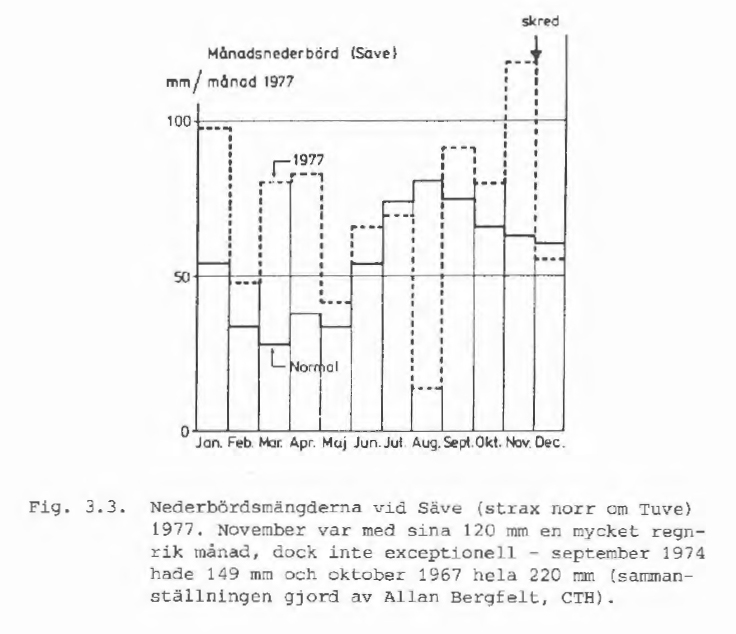
Source: SGI, Report No 10, Tuveskredet
1977-11-30.
The above diagram indicates that November was not
exceptional. There was speculation in the media that the abundant
rainfall was the main cause of the landslide. The researchers rejected
this theory.
Another theory dealt with was the
culvert located at Tuve Kyrkväg.
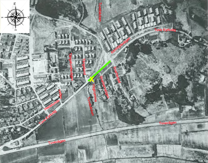
The
culvert was at the yellow X. Its task was
to conduct the water from Tuvebäcken
(a creek) under the Tuve Kyrkväg
and further east in the direction of the Göta River.
There had been information from residents in the area
that the heavy rainfall in November meant that the culvert did not
have the capacity to drain all the water from Tuvebäcken. The section of
Tuve Kyrkväg which is green and shown in
the picture above had undergone
a rebuild in the 1930s. The road was built on a embankment
that was about 1- 1.5 m high. At the culvert
the height was about 3 m. This embankment came to function as a pond when the water
collected on the west side of the section. The area was flooded.
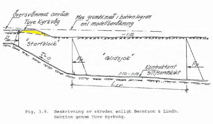
The above sketch shows a cross section of Tuve
Kyrkväg at the culvert. To the left is
the
embankment visible. The pressure from the
water-soaked clay against the "startblock" is
indicated by the designation PW
(water pressure). Above the clay, water was
collected against
the embankment. Source:
SGI, Report No 10, Tuveskredet 1977-11-30.
The private investigators have
found that the reason for the flooding was that
the
culvert was clogged. Here the Nazis had succeeded
to prevent the flow through the culvert by clogging it. The area west of Tuve Kyrkväg
became water-sick. Shortly before the landslide,
witnesses had observed that a crack had formed in the roadway along the
green section (about 80 m). Finally, the pressure on the
embankment became so heavy that it collapsed. The start
of the Tuve landslide was a fact. The
"startblock" was on sloping bedrock. The shear strength of the clay was
equal to zero in the block, which caused it to slip away when the
embankment collapsed. Then sliding chunk ("glidsjok")"
after sliding chunk slid off in
a south-easterly direction and crashed into the river valley. From a
geotechnical point of view, the choice of a dam
at the culvert was optimally. As shown in the sketch above, the
"startblock" sloped relatively steep, which facilitated the initiation
of the landslide. Thereupon the "startblock" pushed the first
sliding chunk
and a huge landslide had started. People with expert knowledge of geology may have
been responsible for the selection of this site for the start of
the landslide. It is likely that the
perpetrators had access to maps used when the area was exploited in the
1960s. Then there were maps showing the appearance of the bedrock at the
"green" section.
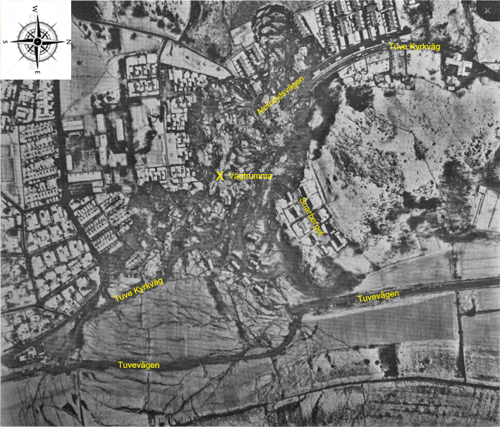
Aerial photo showing Tuve after the
landslide. Notice how the clay masses moved.
Farthest
down you can see how Tuvevägen was pushed down.
Six of the fatalities were living at addresses
at Almhöjdsvägen. In the middle of the picture I
have marked the location of the culvert with
a yellow X
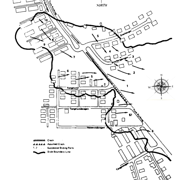
Sketch showing the direction of movement of the
landslide masses. The black outline marks
the edges of the landslide.
Source: The National Academies Press, The Landslide at Tuve.
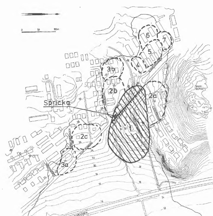
Scheme of the Tuve
landslide. The "Spricka" (Crack)
arrow points to where
the culvert
was
located. Tuvebäcken is visible below. Source: SGI, Report
No 11a, Tuveskredet. Slutrapport.
Through interviews of witnesses to the landslide,
researchers have been able to compile the landslide
order:
Area 1.
Shortly after 4 pm, a crack occurred at Tuve
Kyrkväg. The crack is highlighted in the sketch
above. Parts of the Tuve Kyrkväg collapsed in a
southeastern direction. The houses at
Snarbersstigen slid away in a south-easterly direction.
Area 2 a.
The houses at
Snarberget slipped away in a retrogressing slide.
Area 2 b.
The houses at
Tångelund slid off at the
same time as the houses in Area 2 a.
Area 2 c.
The houses at Hedelundsvägen slid off at about
the same time as the houses in Area 2 a and 2 b.
Area 3 a.
The houses at Tångenvägen slid off.
Area 3 b.
The remaining houses
at Tångelund slid off at about the same time as the
houses in area 3a.
Area 4 - 7.
A retrogressing landslide occurred at Almhöjdsvägen.
The row houses slid away one by one.
The entire landslide was over after about 4
minutes. It was about 800 m long. The width
of it was greatest where
the landslide stopped, about 600 m. The height from the ground surface
to the bottom of the landslide bed was about 10 m
at its greatest.
In other operations that have had the nature of disaster, the CIA has
always ensured that the selected target group is hit as hard as
possible. My assumption is that Jehovah's had
great insemination activity at
Tuve at that time.
After the landslide, some areas were rebuilt.
Here they made reinforcements of the soil layer down to the bedrock with
the help of injected concrete.
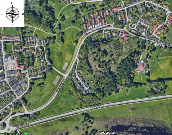
The Tuve
landslide area today.
Here you can download reports on the Tuve
landslide:
SGI, Rapport No 10. Tuveskredet 1977-11-30 (1981).
sgi-r10.pdf
(Swedish, 7,19 MB)
SGI, Rapport No 11a. Tuveskredet Slutrapport (1984).
sgi-r11a.pdf
(Swedish, 5,22 MB)
The National Academies Press, The Landslide at Tuve (1980).
national_acdemies_report.odt
(English, 7,28 MB)